
Erupting from a blue and green surface of friable, volcanic rock, the Japanese islands seem likely at any given moment to burst into flame. Kyushu, the southernmost island in this quivering chain, always seems closer to the fire and hell pits than the rest of the archipelago.
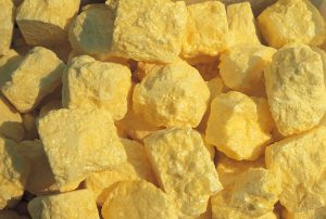
Yellow lava rock from the calderas is sold as a tourist item in Aso.
Flying above the plains and hills of what would become the Aso-Kuju National Park area in Kyushu in the early 1960s, English writer James Fallow, in his travel book Japan Behind the Fan, described the sun “shafting low over a golden and green landscape tinged with brown and yellow, all the colors of ripeness.” The description that holds equally true today. This perspective is fully experienced by passengers who opt to take the switchback train from Kumamoto City to the unassuming little town of Aso, one of the best ways to approach the region.
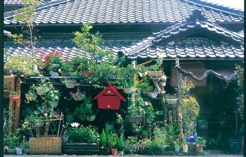
 The town, situated within Aso-Kuju National Park, is little more than a base for renting cars, finding accommodation and checking on bus times to the caldera, though there are restaurants here, a hot spring public bath or two, and pleasant private gardens. It is the Aso mountains and volcanoes, though, that dominate the life and livelihood of this area, blotting out almost every other physical feature. Another English writer, the late, much missed Alan Booth, noted the vastness of its outline when, looking for the moon as a navigational point on part of the journey recounted in his classic The Roads to Sata, he commented that “I couldn’t see it – only the empty space in the sky where the stars were hidden by the shape of Mount Aso.” The Aso region’s population of 70,000 is swallowed up in the vastness of its grassland and mountain slopes. These deep, eruption-furrowed trenches and grass-covered gutters reminded me of the Mongolian Steppes.
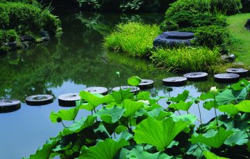
The ideal way to explore the area beyond the main road connecting the caldera with the town would be by bicycle (a steep ride up, a blissful one down) or, time permitting, on foot. The undulating farmland contiguous with the southwestern slopes of Aso-zan is the least touristed, requiring just that extra effort and time to reach. Tracks lead to dark green gorges gleaming with shallow streams cool to the touch even in summer, to horse-grazing pastures, and to dark, mossy slopes and hillocks that look as if tons of spinach had been poured over them. Inside the caldera walls, an ancient fence of curling volcanic rock, the land is greener and darker, its grasses more luxuriant than elsewhere, its earth more fertile. The floor of the caldera is a patchwork of rice-fields and other crops, vigorously farmed by families, some of whom have lived in the area for generations, maintaining a close bond with nature. Once in the caldera, a striking shape materializes on the right side of the road. This is the grass-covered hill known as Komezuka, which, as the name indicates, means inverted rice-bowl. Equally suggestive of the ziggurat or burial mound of some ancient nature cult, it is a configuration of great beauty.
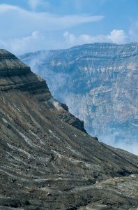
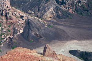
The fire and time-seared slopes of Nakadate.
Buses en route for Nakadate, the massive, highly active crater that is for many the highlight of an Aso trip, stop a little further on at Kusasenri-ga-Hama, a circular plain that was originally a minor crater. A large pond at its center serves as a watering hole for cattle and horses. It is possible to hire one of these nags for a carefully escorted trot around the plain, but one suspects that most of the horses picturesquely grazing in Aso’s vast pasture are destined to end up served as basashi (raw horse meat) along with other Kyushu specialties like salted squid fried in butter, broiled baby clams and grilled sparrow in the nearby restaurants of Kumamoto.
The Aso Volcano Museum, with its 170 degree multi-screens relaying images of the crater and its catchment area, is also here. This is not a required visit given that superb views assail the visitor at every turn, although two cameras attached to the crater wall, relaying continuous images of the cone’s volcanic activity, provide some interest. Nearby is the decidedly missable Music Box Museum, one of those strange anomalies of Japanese tourism that seem almost like an afterthought.
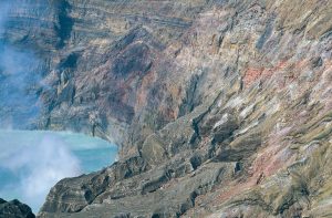
Colorations add interest to the surfaces of the caldera.
Signposts along the roads to Nakadate welcome visitors to Hi-no-Kuni, the “Land of Fire.” The generic Mt. Aso is actually a series of five volcanic cones, it’s massive caldera stretching to a circumference of 128 km. Of the five peaks, Daikanbo (at 936m), is the highest. Nakadake, emitting sulphurous fumes and high-temperature gases that occasionally bring hiking above the basin to an abrupt halt, is an active volcano, which last erupted in 1979. The paths around and above Nakadake have eruption shelters, domed concrete buildings like sci-fi homes or observatories, with loose rocks strewn around them as evidence of very real seismic activity. Plumes of smoke waft from its rumbling cracks and water surfaces, bubbling against a rock face as coarse as freshly lanced boils.
All this subterranean activity means superb hot springs, most found in the caldera itself, though there are onsen retreats tucked away in the highlands nearby as well. Here too is Futae Pass, a stone-paved route over the hills that has been preserved in much the same state as when Daimyos and their families made their mandatory travels from the region to Edo. A statue of temporary Kumamoto resident Soseki Natsume stands here in a benign pose, more suited to a kindly Confucian elder than the image of a brilliant but neurotic writer that biographers and relatives have left us.
A cable car takes visitors to the top of Nakadate, providing awesome views into the depths of the crater and it’s malodorous blue-green lake. Hikers up to the challenge can follow a gloriously uncrowded path to the summit of Nakadake for a closer look. A popular hike starts at the top of the ropeway, proceeds to Mt. Takadake, and then goes around the crater rim before descending to Sensuikyo Gorge.
Time can stand still in the strange landscape of Sunasenri.
Less traversed by tourists, but equally dramatic is Sunasenri, a caldera topped up with ash to form a sea of black, volcanic sand that can be discovered a little east of Nakadake. Here, among the footprints of the odd visitor, Himalayan-style cairns and some nasty gorges and overhangs, one expects to come across the bones and fossils of stranded sea creatures, or a rusting lunar vehicle. Fascinated by the landscape and geology of this dead zone, time can dissolve. When I returned to the parking lot, I discovered that the last bus back to town had left at 5.00 pm. The three-hour walk to Aso Station was mostly downhill and with little traffic. In darkness, however, without the benefit of any street illuminations or flashlight to read the road signs, the walk through the pitch-black pine forest is not especially recommended.
TRAVEL INFO
From Kumamoto, the Kyushu Kokusai Kanko Bus runs a regular schedule to Aso. The JR Hohi Line switchback train completes the Kumamoto to Aso run in 90-minutes, and has great views. Aso is green and lush from May through the summer months, its grasslands impressive but russet-colored at other times. Shukubo Aso (0967-34-0194) is a magnificent traditional minshuku in an old farmhouse. The food is good and the owner speaks English. Aso-no-Fumato is a great alternative, with rooms at ¥4,500 without meals. There are few restaurants in Aso, so eating at your lodgings is the best option.
Festivals & Events
Aso’s Christmas Balloon Fair (23-24 December) features a large number of hot air contraptions floating majestically over the landscape. Aso’s big festival, the Hiburi-Shinji (Sacred Fire Ritual), falls on 3 March.
Story and Photographs by Stephen Mansfield
From J SELECT Magazine, September 2010


Recent Comments